

The Mountain Building Phase!
The latest joint survey by China and Nepal has revealed that the Mount Everest is about 3ft higher than the most commonly accepted figure for its height! However, going by the earthly statements that may sound philosophical, rather than valid, one cannot measure the same mountain twice. The tools and methods of measurement have advanced a lot, but pinning the true height of a mountain can still pose a virtually insurmountable challenge!
The first recorded attempt at measuring the height of Mount Everest, using modern calculations, had come in 1886, when surveyors – commissioned by the then Surveyor General of India George Everest – estimated its height at 29,002ft. Without going into the sines and cosines of the craft, it would suffice to say that using accurate measures of distance and multiple readings of angles from different positions, it is possible to use trigonometry to successfully determine the elevation of any feature. A key instrument in this exercise is the Theodolite, which helps in measuring angles. It is much like an instrument one may have observed engineers using while constructing roads.

As it turned out, the height determined by officials of the British Raj was quite close to the one Indian officials would compute in the 1950’s, using more modern instruments and techniques: 29,028ft or 8,848mt! It is still the most cited figure for Everest’s height.
The key tool employed by the Chinese and Nepalese surveyors was a GPS receiver, which was carried to the peak of Mount Everest. The factor of time taken for signals to travel from the receiver to multiple satellites from fixed objects provides a highly accurate approximation of the location and the elevation of the peak. However, while GPS and similar systems may have enabled great leaps in pinning heights, measuring a mountain depends significantly on several moving parts. GPS can tell one where the top is at, but to find the height of a mountain, it is equally critical to know where the bottom lies… because mountains are measured by their elevation from the sea level.

Nearly 170 years ago, Everest’s crew, led by Mathematician Radhanath Sikdar, had solved the problem of sea level by actually working their way up from the Bay of Bengal by employing a network of line-of-sight stations until Everest itself was visible and could be measured, using trigonometric formulae. Another factor that proves contentious is whether to calculate the depth of the snow on a mountain peak as part of its height. The Nepalese surveyors used a ground-penetrating radar to actually measure the height of the snow standing on top of Everest’s rocky crest. However, in the past, it was debated whether the snow should be part of the calculation…
To accurately determine sea level while interpreting the GPS data, scientists, now, rely on two models that conceptualise the shape of the Earth: Ellipsoid, which presents the Earth’s surface as smooth and uniform, and is used to measure geographical coordinates; and Geoid, a model that takes into account gravity and how the rotating Earth bulges at the Equator and flattens at the Poles. The Geoid Model is a close proxy for mean sea level. Calculations, involving the Ellipsoid and Geoid heights, finally give the orthometric height or the height above the sea level.
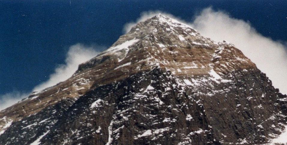
Everest, much like the rest of the Himalayan range, is growing by about half a centimetre every year as a result of tectonic-plate collisions. The Indian plate pushing into the Eurasian plate for at least 40 or 50 million years is causing the peak to rise, though almost negligibly. However, earthquakes have the opposite effect. They can reduce a peak’s height. The 7.8-magnitude earthquake that had struck Nepal in 2015 possibly reduced Everest’s snow cap. Scientists have found that some other peaks near the epicentre saw their heights shrink by about a metre after the quake!
A 1934 earthquake was estimated to have cut the mountain by about 2ft. Nepal’s Survey Department said that the 2015 disaster was a key reason behind measuring Everest’s height again…

(Sources: National Geographic, NOAA, Slate, Media reports)
Boundless Ocean of Politics on Facebook:
https://www.facebook.com/boundlessoceanofpolitics/
Boundless Ocean of Politics on Twitter:
https://twitter.com/kousdas?s=09
Boundless Ocean of Politics on Linkedin:
https://www.linkedin.com/company/boundless-ocean-of-politics
Contact us: kousdas@gmail.com
