

‘Lost Continent’ Revealed In New Maps…
There was a separate continent, called Zealandia, on Planet Earth in the past, apart from the existing seven continents. Scientists discovered this continent in 2017. They recently drew the map of the eighth continent, in a rare first. Hence, the global community has come to know how much the lost continent covered the world.
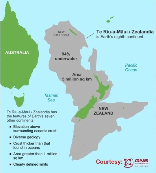
Zealandia, also known as Te Riu-a-Māui or Tasmantis, used to exist 83-79 million years ago. According to scientists, Zealandia is an almost entirely submerged mass of continental crust in Oceania that subsided after breaking away from Gondwanaland. Scientists have claimed that the eighth continent is nearly one billion years old! They have explained that Zealandia formerly belonged to the ancient supercontinent of Gondwana, which was formed about 550 million years ago. The entire continent was submerged at some point of time due to geological changes. Only some islands remain on the water, and one of them is New Zealand. There are some other islands of similar shape around New Zealand. These islands and other areas encompassed by the continent include New Caledonia and other Australian territories belonging to the Lord How Island. However, New Zealand and other islands are only 6% of Zealandia, as the remaining 94% is submerged under water.
A Dutch sailor had talked about this continent 375 years ago. In 1642, Abel Tasman, who was desperate to uncover the Great Southern Continent, claimed that he had got some valuable information about the surrounding land, including the existence of a large landmass to the east, from the local Māori people. In 2017, geologists found that the Dutch sailor was right, as the continent had been hiding in plain sight all along.
The BBC recently reported that Zealandia emerged as a vast continent, spanning a staggering 4.9 million square kilometres, making it approximately six times the size of Madagascar. A team of scientists involved in this groundbreaking discovery is of the opinion that Zealandia was the smallest, thinnest and youngest continent on the Planet Earth. Scientists are currently trying to find out the history of Zealandia by examining the rocks submerged under the Pacific Ocean.
The BBC also reported that a team of seismologists and geologists has created a newly refined map of Zealandia. The updated map has shown the location of the magmatic arc axis that forms the lost continent, as well as a number of important geological features. They refined the map by using the data obtained from dredged rock samples recovered from the ocean floor.

It took so long to draw the map of the continent because Zealandia was not nearly as well studied as the conventional continents, as a large part of it was submerged beneath the ocean, resulting in inconsistencies in its form and structure.
Boundless Ocean of Politics on Facebook
Boundless Ocean of Politics on Twitter
Boundless Ocean of Politics on Linkedin
Contact: kousdas@gmail.com
